 CastlegarMy
Home
CastlegarMy
Home
|
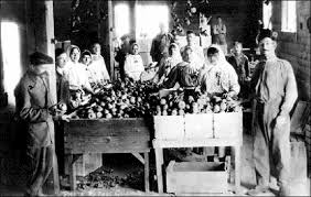
History of Castlegar On 5 September 1811, David Thompson arrived at the location where Castlegar now sits, where he camped near the mouth of the Kootenay River. A plaque dedicated to David Thompson can be found on the east bank of the Columbia River overlooking the present day site of Castlegar. The first settlement in the area was West Waterloo, now known as South Castlegar. There was widespread provincial interest in gold prospecting in the late 19th century, and by 1895 there were forty houses in Waterloo. The town boomed until the end of the century when interest in the local mines declined. Castlegar takes its name from Castlegar, County Galway in Ireland, the ancestral home of townsite founder Edward Mahon. (Castlegar is on the eastern boundary of the city of Galway.) The city was planned in 1897. Around 1902, the Canadian Pacific Railway (CPR) built the bridge at Castlegar and laid the wide gauge railway tracks to Trail. They put in a box car station at the old Waterloo trail crossing and called it Kinnaird Station in honour of Lord Kinnaird who was a shareholder in the CPR. There was little in Castlegar until after the completion of the CPR bridge. A Mr. Farmer built the first store in town, housing both the post office and the town hall. William Gage built the Castlegar Hotel in 1908, standing until 1982 when it was destroyed by fire. Also in 1908, the first schoolhouse was built by a few local residents who bought the lumber and erected the building. A dance pavilion, garage, tourist cabins and a slaughterhouse had all been established by 1925. On 30 October 1946, Castlegar was incorporated into a village, then in 1966 into a town. It amalgamated with the neighbouring town of Kinnaird into a city on 1 January 1974, effectively doubling the population. On 20 May 2004, the City's boundary was extended to include the Blueberry Creek Irrigation District. Native history " Qepitles" was a site on the north side of the Kootenay River, just above the junction with the Columbia River. Native implements (arrowheads, pestles, etc.) have been found along the nearby Arrow Lakes. A reconstructed kekuli dwelling was formally located on Zuckerberg Island, at the confluence of the Kootenay and Columbia rivers. Doukhobor history |
![]()